Orion-I flew on 9 April 2006. Launch was at
approximately 10:50 a.m., with burst and descent beginning around 12:12 p.m.
(see discussion below).
The payload was
recovered in the Macedonia community of Jackson County on County Road 49,
just across the line from DeKalb County, at approximately 4:30 p.m.
The landing site was within 10 miles of the predicted
landing site.
KI4NMN-11
APRS data (144.39) ended around Ditto Landing, so recovery was
accomplished by direction-finding the NV4B telemetry signal (144.34) and
once close, the KG4WSV audio beacon (146.64).
The landing site was 39 air miles from the launch site. The actual
path taken by the balloon covered about 50 miles.
This graph depicts the data received by the CPE
Telemetry Team:
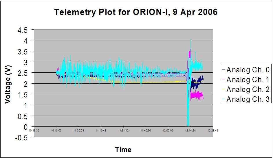
We believe that Analog 0 and 1 are accelerometer
channels, Analog 2 is temperature, and Analog 3 is the gyroscope.
The launch occurred shortly before 10:50. One can
notice the temperature drop off as time goes on, rising slightly around
12:05. Jason, KG4WSV, attributed this to passing through a layer of
warmer air as the balloon continued to ascend.
Between 12:11:17 and 12:12:12, no data was received (this can be seen in the
raw data file). When the signal
returned, the data was highly anomalous, as can be seen in the graph.
It is believed that the balloon burst sometime during this period, and the
data loss is due to tumbling, as evidenced by the gyroscope data. After
12:11:17, the temperature first falls, presumably as the balloon falls back
into the colder air below, then begins to rise rapidly--at a greater pace
than the cooling that occurred after launch--as the balloon quickly
approaches the earth's surface.
It is interesting
to note that when the gyroscope went extremely negative (<2.5 volts), one of
the accelerometers returned highly positive (>2.5 volts) data; when the
gyroscope went positive, that same accelerometer channel then went negative. I'll
leave it to the data analysis team to figure that one out!
The data stabilized around 12:15 and remained in the same
state until it could no longer be decoded.
The
data signal was lost after 12:22:52 as the balloon became too low to the
ground to copy. However, telemetry module continued to transmit until
the payload was recovered at 4:30 and power was removed. Without this
nearly-continuous 400 mW signal to guide recovery, the payload might never
have been found, as the only other working signal on board was KG4WSV's 40
mW audio beacon, which was too weak to be heard until we were within about
0.5 miles of the package.
More details of the flight, including a detailed
story of the recovery, will be posted here as I have time.
--Chris Arthur, NV4B
CPE Telemetry Team
